Santa Cruz County Watchdog

Awareness, Accountability, Action

Santa Cruz County Watchdog is dedicated to helping residents, government, academic, environmental, and mining interests find equitable solutions to mining challenges
  • US Forest Service Natural Resources Management

    From the USDA Forest Service website –

    “Water is one of the most important commodities on Forest Service lands, and the cleanest water flows from healthy, forested watersheds. The most effective way to approach ecological issues is to consider them at a watershed level.” You can read more here.

    We must hold the Forest Service accountable for mandating the implementation of policies and procedures outlined on its own website, not simply rubber-stamping the least cost and/or easiest solution for water disposal.

  • Department of the Interior Nature-Based Solutions Roadmap

    From the USGS website:

    “Nature-based solutions provide benefits to both nature and people, simultaneously addressing the issues of climate change and biodiversity loss. The Department of the Interior (DOI) manages more than 480 million acres of natural and working lands in the United States, presenting a significant opportunity to leverage nature-based solutions to contribute to greenhouse gas reduction targets, equitably build ecosystem and community resilience, and deliver additional co-benefits for ecosystems and people. This project created a DOI Nature-based Solutions Roadmap document to provide consistent and accessible information about the broad range of nature-based strategies.”

    “The DOI Nature-based Solutions Roadmap includes general information to support implementation of nature-based solutions, such as community engagement, Indigenous Knowledges, and adaptive management. It also includes detailed summaries for 29 specific nature-based solutions strategies identified as relevant to DOI goals, which address technical approaches, expected benefits, example projects from throughout the United States, and links to additional tools, training, and resources. The Roadmap will be used to support the work of DOI staff in the implementation of nature-based solutions to benefit both nature and people.”

    You can learn more about the Department of the Interior Nature-Based Solutions Roadmap here.

  • Nogales City Council Meeting Presentation

  • Turning Lemons into Lemonade

    There has been a lot of talk about how much water South32 has been approved to discharge at the Hermosa Project as part of its dewatering program required to access critical minerals. In fact, the US Forest Service has approved South32 to extract and discharge up to 6.5 million gallons of water per day at the Hermosa Project – that’s 20 acre feet of water per day for the life of the mine which may exceed 50 years.

    That’s a lot of water, but it need not be treated as an afterthought. It can be strategically released in the mountains surrounding the Hermosa Project to recharge surface water aquifers that feed Harshaw and Sonoita Creeks and the Santa Cruz River via the San Rafael Valley. Here is a map showing some of the possible discharge locations around the mine:

    Dataset provided by the U.S. Environmental Protection Agency (EPA) WATERS (Watershed Assessment, Tracking and Environmental Results System)
    Discharge Locations

    The ‘blue’ lines represent stream channels, and the ‘orange’ lines represent ridge lines separating catchment basins. Please note that not all stream channels are marked on this map.

    Discharging dewatering and treated water directly into washes and constructing low-tech and low-cost natural rock detention structures downstream of the discharge point has the following benefits –

    • sequester atmospheric carbon in the soil
    • maintain or increase vegetation and biomass
    • extend ephemeral duration and surface-water availability
    • mitigate floods and associated emergency response expenditures
    • promote lateral flows and onsite storage of water
    • control erosion and nonpoint source pollution
    • improve water quality and reduce torpidity
    • reduce ambient temperatures
    • ensure access to water for wildlife all along stream channels

    But, dewatering and treated water is not going to magically start flowing in these catchment basins on its own. It’s up to us to ensure that water is being discharged responsibly. South32 can only discharge water in the Coronado National Forest with US Forest Service permission, so it is critical that we let them know that we support this proposal. Please visit our Get Involved post and contact Local, State, and Federal governments, State and Federal Agencies and South32 to voice your support for discharging dewatering and treated water in the mountains around the mine.

    So, you see, with some imagination, creativity, political will, and a desire to create a brighter future for the next generation of Arizonans, it is possible to turn lemons into lemonade.

  • Get Involved

    South32 will do whatever the US Forest Service (USFS) tells them to do. It’s up to us to ensure that the USFS mandates the best solution for all stakeholders, not the least expensive or easiest to implement. And the best way to do that is for all of us to lobby our publicly elected officials and State and Federal agencies even though they may not have direct control over USFS decisions.

    Please download the e-letter at the bottom of this post to use as a starting point for contacting any of these organizations listed on our Resources page or anyone else whom you think may be interested.

    Our voices must not be silenced.

    ========================================================================

    Re: South32 Hermosa Mine Water Discharge Proposal

    Dear [Recipient],

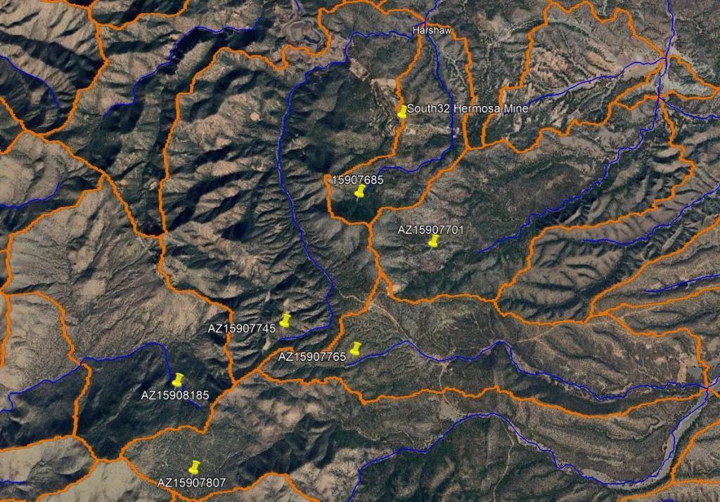
    I am writing to express my support for a water discharge proposal for the South32 Hermosa Mine, located south of Patagonia, Arizona, which is inspired by research from the United States Geological Survey (USGS) and advocated by John Nordstrom. The mine is expected to extract up to approximately 6.5 million gallons of water daily (20 acre-feet) through dewatering. This proposal, based on USGS research conducted in the Turkey Pen watershed in the Chiricahua Mountains, recommends discharging this water directly into washes of selected catchment basins around the mine, coupled with the construction of low-tech, low-cost natural rock detention structures downstream.

    For a detailed overview, see the USGS video: Re-greening a Dryland Watershed – https://www.usgs.gov/media/videos/re-greening-a-dryland-watershed (10 minutes). This approach offers multiple environmental and community benefits:

    1. Carbon Sequestration: Enhances soil carbon storage, contributing to climate change mitigation.
    2. Vegetation Growth: Maintains or increases vegetation and biomass in the region.
    3. Extended Water Availability: Prolongs ephemeral stream flows and surface-water availability.
    4. Flood Mitigation: Reduces flood risks and associated emergency response costs.
    5. Water Storage: Promotes lateral flows and onsite water storage for sustained use.
    6. Erosion Control: Minimizes erosion and nonpoint source pollution.
    7. Improved Water Quality: Reduces turbidity, enhancing water clarity and usability.
    8. Temperature Regulation: Lowers ambient temperatures in the surrounding area.
    9. Support for Local Ecosystems: Ensures water access for ranching and wildlife in and around the catchment basins.

    By adopting this method, the discharged water will benefit Harshaw and Sonoita Creeks and the headwaters of the Santa Cruz River via the San Rafael Valley. The United States Forest Service, in conjunction with South32 Management, must prioritize the responsible discharge of treated and discharged water to maximize benefits for our community, visitors, and the natural environment for future generations, rather than treating the water as an inconvenience to be disposed of in the cheapest manner possible.

    Sincerely,

    [Your Name]
    [Your E-mail Address (optional)]
    [Your Phone Number (optional)]

  • Mining Law of 1872

    The General Mining Act of 1872 is a United States federal law that authorizes and governs prospecting and mining for economic minerals, such as gold, platinum, and silver, on federal public lands. It was signed into law by President Ulysses S. Grant on May 10, 1872, to promote the development of the nation’s mining resources. The law applies to land in the public domain, which is federal land that has never been set aside for a specific use, such as national parks or wilderness areas.

    Critics argue the law is outdated, as it was designed for small-scale prospectors with pickaxes, not modern multinational mining corporations. The law does not require mining companies to pay royalties on the minerals extracted from public lands. As a result, the federal government receives no direct revenue from the extraction of minerals. The law also contains no environmental protection provisions and has resulted in water pollution from abandoned mines, with cleanup costs potentially exceeding $50 billion.

    Federal land managers have stated they cannot deny mining proposals due to the law’s provisions, which treat a mining claim as a right-to-mine. The law has been the subject of numerous reform efforts, with advocates calling for updated regulations to protect communities, the environment, and ensure taxpayers receive fair compensation.

    Under the Mining Law of 1872 South32, the US Forest Service has been approved to discharge up to 6.5 million gallons of water per day (20 acre feet) for the life of the mine. It’s up to us to ensure that discharged water is being treated, meets agreed-upon clean water targets, and is discharged responsibly. You can help by contacting the US Forest Service (USFS), the Environmental Protection Agency (EPA), and your State and Federal elected officials.

  • Water for Me but not for Thee

    In the South32 Landowner Agreement contract proposal sent to landowners, South32 states that South32 will ‘ensure safe access to and use of a suitable replacement water source based on
    Landowner’s prior existing water uses.’ While this provision of the contract proposal does guarantee access to water, it does not provide for any change in a landowner’s water usage over time.

    What happens when a landowner decides to plant an orchard, start a tree farm, install a greenhouse, or needs additional water?

    By agreeing to the terms of the South32 Landowner Agreement contract, as presented, landowners are locking themselves into an agreement that caps access to water while South32 is permitted to discharge up to 6.5 million gallons of water per day for the life of the Hermosa Mine operation.

  • Lies, Damn Lies, and Statistics

    The phrase “lies, damned lies, and statistics” was popularized by Mark Twain in his 1907 work Chapters from My Autobiography. Statistics are not inherently lies, but they can be used to create misleading or incorrect conclusions through data manipulation, data selection, or the improper use of statistical methods.

    In the South32 Landowner Agreement contract proposal sent to residents, South32 states that they are the ‘Final Arbiter’ as to whether they are responsible for changes to a landowner’s water well level and/or water quality. As final arbiter, South32 decides what data is used, how the data is segmented, and what statistical methods are used when determining who is responsible for changes in water level and/or water quality.

    Clearly, South32 has a vested interest in the outcome of any discussion regarding water availability or water quality, just as landowners have a vested interest in any discussion regarding water availability or water quality. However, landowners may not have the educational background, training, or access to the same tools and statistical methods as South32 which puts landowners at a disadvantage when interpreting data or determining responsibility.

    Therefore, a more reasonable approach would be to use a mutually agreed upon third party hydrologist, paid for at South32’s expense, to determine who, if anyone, is responsible for changes in water level and/or water quality. Using a mutually agreed upon third party hydrologist will help ensure that data interpretation and conclusions are unbiased towards either South32 of a landowner.

  • Cone of Depression

    The USDA Forest Service Hermosa Critical Minerals Project Draft Environmental Impact Statement (DEIS) identifies a ‘cone of depression’ up to 58 square miles in size around the mine which will be created by a dewatering program required to access minerals for extraction.

    Per the DEIS, the ‘cone of depression’ will intersect SH82 south of Patagonia –

    Some residents who live within the ‘cone of depression’ have received a Landowner Agreement contract proposal from South32 whereby South32 guarantees water security for the Landowner with conditions…

    If this is the maximum extent of the ‘cone of depression’, why are residents who live outside the ‘cone of depression’ also receiving the Landowner Agreement contract proposal?

  • Re-greening a Dryland Watershed

    Here is a 10-minute USGS video that perfectly describes how we can responsibly use Mine dewatering discharge for the benefit of our community and the environment.

    https://www.usgs.gov/media/videos/re-greening-a-dryland-watershed

    Discharging water into the headwaters of washes surrounding the Mine, will recharge the Santa Cruz River and Harshaw Creek.

January 2026
M T W T F S S
 1234
567891011
12131415161718
19202122232425
262728293031